Log in
All resources
Create a design
1,097 Free Artworks of Coats Of Arms On Maps
bibliothèque nationale de france
maps in the rijksmuseum amsterdam
prints of cartouches in the rijksmuseum amsterdam
novum ac magnum theatrum urbium belgicae
civitates orbis terrarum. contrafactur und beschreibung von den vornembsten stetten der welt. liber tertius
drawing
digital library of university of wroclaw
prints of coats of arms in the rijksmuseum amsterdam
maps by willem and johannes blaeu
hendrik de leth
maps of lake geneva by jacques goulart
bibliothèque nationale de france
1750s maps of the netherlands
hendrik de leth
bibliothèque nationale de france
maps by thomas kitchin
maps by john rocque
wilton house
maps by nicolas sanson
1720s maps of france
mappe-monde by guillaume delisle (18th century)
1700s maps of the world
1640s maps of ireland
baroque
mappe-monde by guillaume delisle (18th century)
claude auguste berey
works after map of amsterdam, 1544
maps in the rijksmuseum amsterdam
maps of the course of the rhine by guillaume sanson
bibliothèque nationale de france
bibliothèque nationale de france
cartouches by tomas lópez
prints by pieter van den berge in the rijksmuseum amsterdam
maps in the rijksmuseum amsterdam
map of the circle of lower saxony by sanson
bibliothèque nationale de france
bibliothèque nationale de france
guillaume sanson
maps by willem and johannes blaeu
wachtendonk in the 1650s
maps of andalusia by mercator-hondius
bibliothèque nationale de france
17th-century maps of the spanish empire
maps of the spanish netherlands
maps of portugal by fernando álvares seco
bibliothèque nationale de france
maps of aachen by braun & hogenberg
bibliothèque nationale de france
maps of huy by braun & hogenberg
bibliothèque nationale de france
flemish prints in the british museum
prints by jacob de gheyn (ii)
flemish prints in the british museum
prints by jacob de gheyn (ii)
prints of cartouches in the rijksmuseum amsterdam
maps in the rijksmuseum amsterdam
maps in the library of congress
1700s maps of ukraine
maps in the rijksmuseum amsterdam
old maps of arnemuiden
maps of the course of the rhine by guillaume sanson
bibliothèque nationale de france
maps in the rijksmuseum amsterdam
maps by isaak tirion
collection cartographic documents from het utrechts archief
laurens praalder
maps by thomas kitchin
maps of wales
maps in the rijksmuseum amsterdam
old maps of vlissingen
bibliothèque nationale de france
1698 map of evesché de meaux
maps by pieter mortier
le neptune francois
bibliothèque nationale de france
maps of limousin by jean fayen
drawings by jacob toorenvliet in the rijksmuseum amsterdam
pen and ink drawings in the rijksmuseum amsterdam
carta hydrographica y chorographica de las yslas filipinas
baroque painting
maps of portugal by fernando álvares seco
bibliothèque nationale de france
maps in the rijksmuseum amsterdam
bequest of f.g. waller
baroque painting
animals on maps
collection cartographic documents from het utrechts archief
laurens praalder
bibliothèque nationale de france
johannes le francq van berkhey
maps in the rijksmuseum amsterdam
17th-century maps of south asia
maps of aachen by braun & hogenberg
maps in the rijksmuseum amsterdam
1830s maps of puerto rico
nathaniel currier
bibliothèque nationale de france
hendrik de leth
maps in the rijksmuseum amsterdam
rauwerderhem
maps in the rijksmuseum amsterdam
maps by isaak tirion
bibliothèque nationale de france
maps of limousin by jean fayen
novum ac magnum theatrum urbium belgicae
maps in the rijksmuseum amsterdam
prints by wenzel hollar in the british museum
baroque
maps of the iberian peninsula by mercator-hondius
maps by pieter van der keere
l'espagne divisée by guillaume sanson
1680s maps of the iberian peninsula
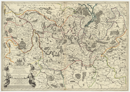
le marquisat et eslectorat de brandebourg qui fait partie du cercle de la haute saxe divisé en ses principales marches... - par le sieur sanson ; cordier sculpsit - btv1b532025368
sanson maps of the circles of germany
beschrijvinghe vande zeeusche eijlanden, soe die op hare stromen geleghen zijn, met een deel vande zee custen van vlaenderen ennde hollant - btv1b532255648
bibliothèque nationale de france
beschrijvinghe vande zeeusche eijlanden, soe die op hare stromen geleghen zijn, met een deel vande zee custen van vlaenderen ennde hollant - btv1b532255648
bibliothèque nationale de france
etchings in the rijksmuseum amsterdam
maps in the rijksmuseum amsterdam
beschrijvinghe vande zeeusche eijlanden, soe die op hare stromen geleghen zijn, met een deel vande zee custen van vlaenderen ennde hollant - btv1b532255648
bibliothèque nationale de france
maps of île-de-france by françois de la guillotière
bibliothèque nationale de france
maps of limousin by jean fayen
gabriel tavernier
die zee caerte van portugal; tusschen camino en montego, alsoe dat landt all daer in sijn ghedaente is, met alle sijne haeven enn ondiepten, met groeter naersticheijt en vliedt ghecorrigeert - btv1b531945351
bibliothèque nationale de france
die zee caerte van portugal; tusschen camino en montego, alsoe dat landt all daer in sijn ghedaente is, met alle sijne haeven enn ondiepten, met groeter naersticheijt en vliedt ghecorrigeert - btv1b531945351
bibliothèque nationale de france
fossa sanctae mariae quae et eugeniana dicitur vulgo de nieuwe grift - btv1b532255218
maps of venlo by willem and johannes blaeu
die zee caerte van portugal; tusschen camino en montego, alsoe dat landt all daer in sijn ghedaente is, met alle sijne haeven enn ondiepten, met groeter naersticheijt en vliedt ghecorrigeert - btv1b531945351
bibliothèque nationale de france
british library king's topographical collection
map of paris by françois van hoey
bibliothèque nationale de france
joachim ottens
battle of the nile
cooper willyams
prints of cartouches in the rijksmuseum amsterdam
maps in the rijksmuseum amsterdam
collection drawings and prints from het utrechts archief
provinciale staten
prints of cartouches in the rijksmuseum amsterdam
etchings in the rijksmuseum amsterdam
old maps of mainz
baroque
maps of venlo by willem and johannes blaeu
maps in the rijksmuseum amsterdam
novum ac magnum theatrum urbium belgicae
maps in the rijksmuseum amsterdam
old maps of the strait of gibraltar
maps in the rijksmuseum amsterdam
prints of cartouches in the rijksmuseum amsterdam
maps in the rijksmuseum amsterdam
map of the circle of bavaria by sanson
louis cordier
mappe-monde geo-hydrographique (sanson and jaillot, 1674)
louis cordier
maps in the rijksmuseum amsterdam
maps by willem and johannes blaeu
maps in the rijksmuseum amsterdam
old maps of brussels
prints of cartouches in the rijksmuseum amsterdam
maps in the rijksmuseum amsterdam
bibliothèque nationale de france
hendrik de leth
prints of cartouches in the rijksmuseum amsterdam
maps in the rijksmuseum amsterdam
old maps of bologna
gregorio monari
maps of portugal by fernando álvares seco
bibliothèque nationale de france
novum ac magnum theatrum urbium belgicae
maps in the rijksmuseum amsterdam
novum ac magnum theatrum urbium belgicae
maps in the rijksmuseum amsterdam
civitates orbis terrarum. contrafactur und beschreibung von den vornembsten stetten der welt. liber tertius
maps of essen by braun & hogenberg
civitates orbis terrarum. contrafactur und beschreibung von den vornembsten stetten der welt. liber tertius
maps of lebrija by braun & hogenberg
civitates orbis terrarum. contrafactur und beschreibung von den vornembsten stetten der welt. liber tertius
maps of leeuwarden by braun & hogenberg
civitates orbis terrarum. contrafactur und beschreibung von den vornembsten stetten der welt. liber tertius
maps of königsberg by braun & hogenberg
civitates orbis terrarum. contrafactur und beschreibung von den vornembsten stetten der welt. liber tertius
maps of loreto by braun & hogenberg
civitates orbis terrarum. contrafactur und beschreibung von den vornembsten stetten der welt. liber tertius
maps of quedlinburg by braun & hogenberg
novum ac magnum theatrum urbium belgicae
maps in the rijksmuseum amsterdam
novum ac magnum theatrum urbium belgicae
maps in the rijksmuseum amsterdam
civitates orbis terrarum. contrafactur und beschreibung von den vornembsten stetten der welt. liber tertius
maps of rotterdam by braun & hogenberg
civitates orbis terrarum. contrafactur und beschreibung von den vornembsten stetten der welt. liber tertius
maps of chartres by braun & hogenberg
civitates orbis terrarum. contrafactur und beschreibung von den vornembsten stetten der welt. liber tertius
maps of romans by braun & hogenberg
civitates orbis terrarum. contrafactur und beschreibung von den vornembsten stetten der welt. liber tertius
maps of eschwege by braun & hogenberg
civitates orbis terrarum. contrafactur und beschreibung von den vornembsten stetten der welt. liber tertius
maps of autun by braun & hogenberg
maps in the rijksmuseum amsterdam
maps by willem and johannes blaeu
prints by frans hogenberg in the rijksmuseum amsterdam
prints of cartouches in the rijksmuseum amsterdam
maps by willem and johannes blaeu
history of straelen
801 - 900 of 1,097
Next page
/ 11


![Aquisgranum, vulgo Aich, ad Menapiorum fines [...] Anno partae salutis. M. D. LXXVI. Coloniae Agripp., between 1576 and 1635](https://cdn.creazilla.com/illustrations/10000850330/aquisgranum-vulgo-aich-ad-menapiorum-fines-anno-partae-salutis-m-d-lxxvi-coloniae-agripp-between-1576-and-1635-md.jpg)


![The course of the river Rhine from its source to its mouth, where all the states and sovereignties above and in the surrounding area are distinguished. [Northern part] / by Mr. Sanson, between 1690 and 1699](https://cdn.creazilla.com/illustrations/10001103886/the-course-of-the-river-rhine-from-its-source-to-its-mouth-where-all-the-states-and-sovereignties-above-and-in-the-surrounding-area-are-distinguished-northern-part-by-mr-sanson-between-1690-and-1699-md.jpg)


![Totius Lemovici et confinium provinciaru quantum ad dioecesin Lemovicensen [sic] spectant novissima et fidissima descriptio / aut. Jo. Fayano M.L., between 1600 and 1650](https://cdn.creazilla.com/illustrations/10000325692/totius-lemovici-et-confinium-provinciaru-quantum-ad-dioecesin-lemovicensen-sic-spectant-novissima-et-fidissima-descriptio-aut-jo-fayano-ml-between-1600-and-1650-sm.webp)


![Totius Lemovici et confinium provinciarum quantum ad dioecesin Lemovicensen spectant novissima et fidissima descriptio / Aut[ore] Jo[hanne] Fayano M[edico] L[emovicense]; G[abriel] T[avernier] F[ecit], 1594](https://cdn.creazilla.com/illustrations/10000258251/totius-lemovici-et-confinium-provinciarum-quantum-ad-dioecesin-lemovicensen-spectant-novissima-et-fidissima-descriptio-autore-johanne-fayano-medico-lemovicense-gabriel-tavernier-fecit-1594-sm.webp)


![[View of Paris]. / Franciscus Hoiamis fecit., François Van Hoey, 1619](https://cdn.creazilla.com/illustrations/10000789014/view-of-paris-franciscus-hoiamis-fecit-franois-van-hoey-1619-lg.jpg)


